
by Fabio Giuseppe Carlo Carisio
The disastrous devastation, the tragic massacre that took place in Turkey and Syria cannot and must not have only an emotional response. That of newspapers and TVs that compete to find the most heartbreaking photo and story. That of politicians who compete for the media scepter of benefactors.
It must also trigger rational reflection. This is why we do not consider it premature but rather a duty towards the families of the victims to seek a reason for what happened that goes beyond resignation to God’s mysterious designs.
As we have anticipated in previous investigations on the highly probable correlation between earthquakes and wells drilling, the greedy hand of man also emerges from the bloody rubble of this apocalyptic drama; increasingly unconscious in his confrontation with nature, as happened with the pandemic triggered by a SARS-Cov-2 virus created in the laboratory to sell and test new dangerous vaccines…
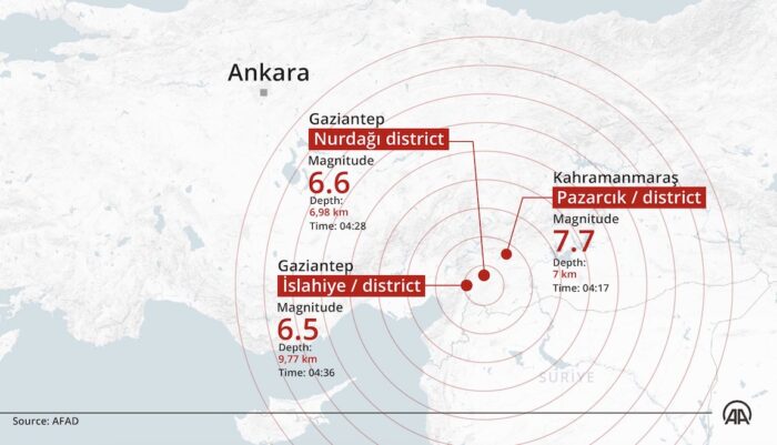
The first exploratory oil drillings in Kahramanmaraş, epicenter of the devastating earthquake that caused thousands of deaths in the Gazientep region, in south-eastern Turkey, and in the neighboring governorate of Aleppo in Syria, were conducted way back in 1991 as attested by a study by a Turkish geologist published in issue 113 of the Bulletin of the Mineral Research and Exploration (source 1 – the links at the bottom of the article).
1 – THE SITE OF THE EARTHQUAKE HAS BEEN IN THE SIGHT OF OIL COMPANIES FOR DECADES
«My first investigations relating to the Kahramanmaraş area took place in 1980 on behalf of a private oil company» wrote Yüksel Önem, one of Turkey’s top petroleum geologists now retired.
«The Taurus mountains, which developed in the conjoining zone of the Anatolian and Arabian Plates, underwent a disruption between Bolkar mountain and Engizek mountain. This can be explained by the fact that the area was traversed and transformed by two ma- jor strike-sup faults situated at Mersin-east Bolkar mountain-Kayseri in the west and Antakya (Hatay)-Elazığ-Bingöl in the east In fact, the east-west oriented 200 km. wide area, covering the gulf of İskenderun and the northern pan of Adana, was compressed and deflected as far as the north of Sarız and the Arabian Plate was dislocated prior to the faulting, and moved circa 120 km».
«Linked to this movement, the Miocene Nappe cover was dragged too far in the exactly opposite direction, i.e., to the south, and changed the original form of the mountain sequence. This relocation resulting from tectonic activities has emphasized, from the viewpoint of the settling of the forma- tions belonging to the Arabian Plate, the importance of the area north of Bolkar mountain-Engizek mountain line or the Taurus sequence and defined the hydrocarbon potential of Elbistan region. As to the Kahramanmaraş area, the fact that the oil-producing formations of the South- east Anatolia are found in this also, it continues to be an important objective».
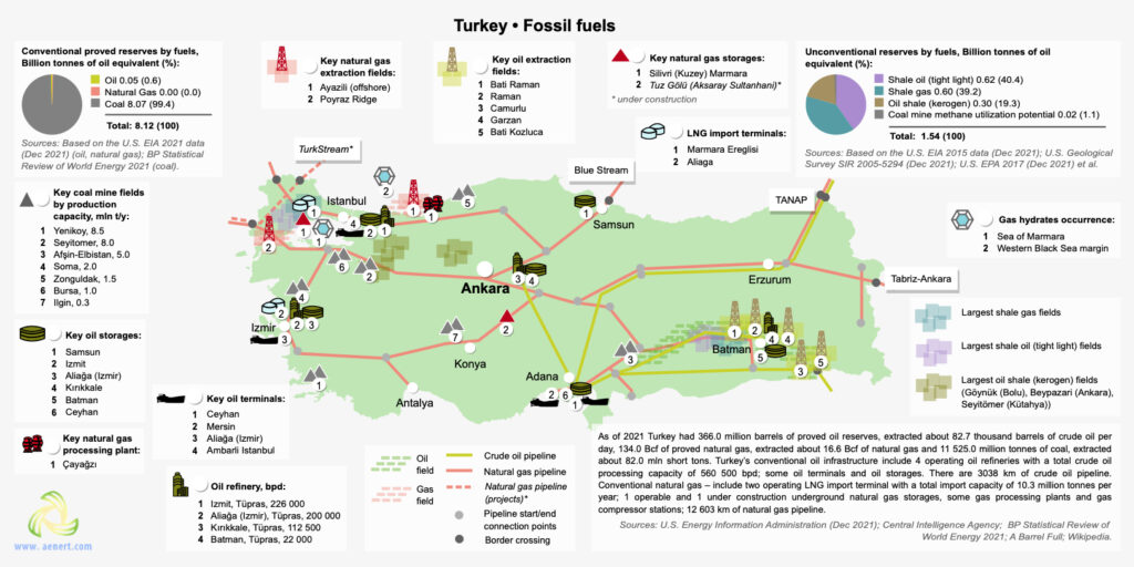
Today around that country made famous by the black gold of the SE (South-East) Anatolian Basin, the vast Dadas Shale oil basin notoriously dangerous to extract due to the “fracking” technique with which rocks are broken at great depths, continues the count of victims is unstoppable.
More than 4,300 dead between Turkey and Syria. This updates the count of the victims of the devastating earthquakes that on Monday, February, 6,2023, destroyed thousands of buildings in southeastern Turkey and northwestern Syria. The Turkish authorities have brought their overall provisional death toll to 2,921, while the Syrian authorities have so far counted 1,444. The number of wounded, in Turkey alone, rose to 14,483.
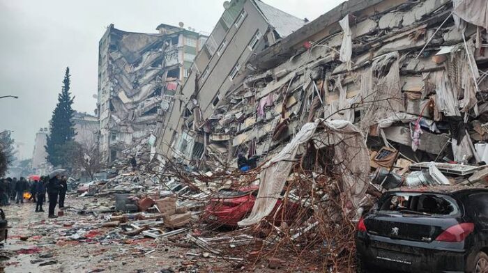
The update is growing hour by hour. In Turkey, at least 5606 buildings collapsed during and after the seismic wake which reached its peak with a 7.9 magnitude shock felt at 02:17 Italian time (04:17 local time + 2 CEST).
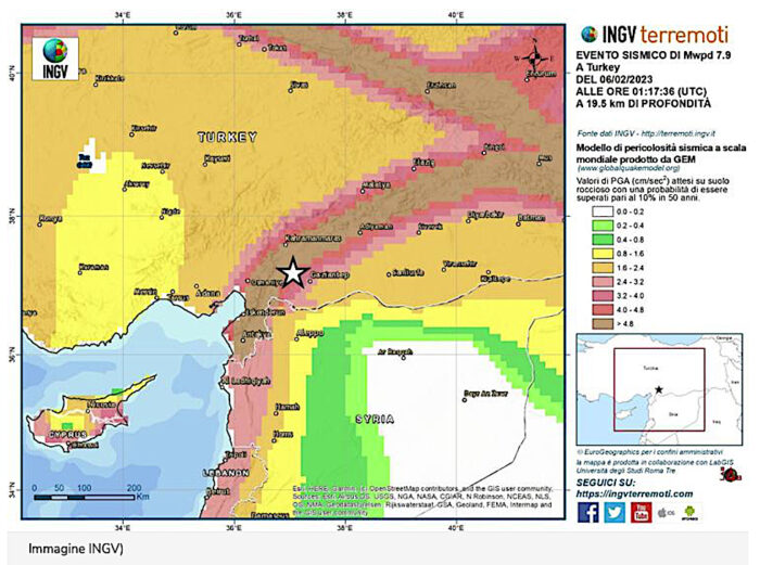
Salvatore Stramondo, director of the INGV Italian National Earthquake Observatory, explained to RaiNews24 microphones that the earthquake produced a release of energy that is about a thousand times higher than the Amatrice earthquake.
After the earthquake, an explosion was reported at a gas pipeline in the southern province of Hatay. This was reported by the Turkish press agency Ihlas, which quotes the operator Botas, according to which gas flows to the provinces of Gaziantep, Hatay and Kahramanmaras have been suspended.
2 – THE DANGERS OF DRILLING THE UNDERGROUND IN SEISMIC AREAS
Geophysical engineer Övgün Ahmet Ercan, according to the Hurriyet website. he said that he had a power of 130 atomic bombs and struck in “a highly seismic area, among those with the highest danger in the Mediterranean”.
Today new tremors have hit the areas already devastated by the seismic swarm of the other night. The strongest of magnitude 5.6 according to the European Mediterranean Seismological Center (or 5.5 according to the United States Geological Institute) with epicenter is near the city of Gölbaşı, population 40,000, at a depth of about 2 kilometers.
“Turkey is located in a highly seismic area crossed by numerous fault systems: the area affected by tonight’s earthquake is considered to have a very high seismic hazard”.
This is explained by the seismologists of the National Institute of Geophysics and Volcanology (Ingv) who have drawn up and just published the worldwide Hazard Model produced by Gem.
But despite the danger, for about twenty years the subsoil has been drilled in search of black gold despite the fact that the cost/risk/benefit ratio has been deemed incongruous by an article of Dr. Armagan Derman (Source 2), director of Türkiye Petrolleri Anonim Ortaklığı (TPAO), the state oil company of Turkey.
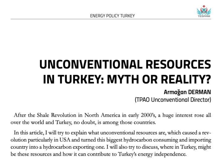
«Unconventional oil and gas, on the other hand, are those hydrocarbons which are pro- duced from the same petroleum system with conventionals, but from a different rock type. These rocks, as stated above, are referred to as shales. If a shale is rich in organic matter it is referred to as Source Rock. Despite conventional reservoirs, it is very difficult to extract oil and gas due to very low transmissibility of fluids. To have econom- ic flow rates, horizontal drilling and hydraulic fracturing is a must».
Derman in his critical text on the drilling of the basin for the search for this specific type of resource of the Anatolian territory and called “Dadas Shale” adds a sentence that today is disturbing.
«Figure-6 shows Turkey’s sedimentary basins. In theory, these are the areas where po- tential unconventional resources are. However, the reality is a little bit different. Turkey, despite wide range of people argue, is not an underexplored country. Petroleum geology of Turkey is well known and even in very high risk basins, wells were drilled».
The research conducted by two Italian geologists was lapidary in warning of the risks of drilling on the Tauro mountain range, 800 kilometers long, which then declines from the summit of 3,734 meters above sea level towards the fragmented offshoots of Gaziantep (860 m asl) and Kahramanmaraş (568 m asl).
«The article deals with the geology of the foothills structure belt of the Taurus Mountains in Southeast Turkey. This area includes three main geological provinces from the south northward: (a) the foreland area, (b) the foothills structure belt, which grades into (c) the Taurus orogenic ridge» wrote in the Abstract of the research published in volume 48 of 1964 of the American Association of Petroleum Geologists the Italians M. Rigo de Righi and A. Cortesini (Source 3).
«As proved by regional geologic studies and wildcat drilling carried out by Turkish Gulf Oil Company, a 10,000-foot thick gravity slide, composed of allochthonous sheets of eugeosynclinal sediments and basic igneous rocks, was found intercalated in an Upper Cretaceous shaly-sandy sequence».
After making their technical observations as insiders, they concluded with an eloquent sentence: «After a general description of the stratigraphic units in the area, emphasis is given to the geology of the allochthonous slide complex. A general hypothesis on the origin and emplacement of these regional gravity slides is outlined. The article ends with some considerations on problems of oil exploration in areas affected by gravity slides».
3 – THE CORRELATION BETWEEN DRILLS, SUBSIDENCY AND EARTHQUAKES
Let’s jump back decades and we get to 2000 when a study by Bulent Coskun reported by Geological Magazine(source 4) introduces a well-known element of danger.
«The older structures were formed during the late Cretaceous movements, but they have been reactivated by latest Miocene tectonic activities with appearance of the Strands of the Dead Sea Fault in the sedimentary basin. The geothermal studies show also that, as a result of the Tertiary transgressions and volcanic activity, the northern and southern sectors of the Gaziantep Basin underwent differing subsidence and structural histories».
Subsidence or subsistence is a slow and progressive sinking of the bottom of a marine basin or continental area.
As we wrote in a previous investigation on the topic, it should be remembered that there are no detailed hydrogeological studies that have examined the feared causal link between drilling, subsidence and earthquakes.
Maria Rita D’Orsogna, a researcher at California State University, who has been following the problem of drilling between the USA and Italy for years, revealed to Adnkronos Italian News agency a series of cases ascertained all over the world where oil activities were linked to telluric movements around the sixth degree of the Richter scale, as reported by the Ocean for Future website which made an interesting synthesis
For example, in the United States many areas have been hit by earthquake swarms right in the areas where fracking was carried out (Arkansas, Ohio, Oklahoma, Texas).
In Italy, the so-called ICHESE COMMISSION (this acronym stands for: International Commission on Hydrocarbon Exploration and Seismicity in the Emilia Region) investigated the possible correlation between oil wells and the earthquakes that struck Emilia-Romagna on 20 and 29 May 2012, killing 27 people and causing hundreds of injuries, reaching an ambiguous and alarming conclusion.
The “Ichese” Commission pointed its finger in particular at an extraction site (Cavone, in Mirandola, in the province of Modena) twenty kilometers from the epicenter of the earthquake: in the conclusions of the report it was said that “it cannot be excluded that the activities mining at the site may have triggered the May 20 earthquake, the epicenter of which is 20 kilometers away”.
4 – HUNT FOR BLACK GOLD NEAR THE EARTHQUAKE EPICENTRE
From 2000 we arrive to 2021 when Sukru Merey of the Department of Petroleum and Natural Gas Engineering, Batman University, Turkey, Can Polat, Department of Petroleum and Natural Gas Engineering, Izmir Katip Celebi University, Izmir, Turkey, and Tuna Eren, Eni International Resources Limited reveal a huge gap (source 5) in their research named “Design of Horizontal Wellbore in Dadas Shales of Turkey by Considering Wellbore Stability and Reservoir Geomechanics”.
WHOLE INVESTIGATION CONTINUES HERE WITH ALL SCIENTIFIC SOURCES
Fabio Giuseppe Carlo Carisio
© COPYRIGHT GOSPA NEWS for Veterans Today only
prohibition of reproduction without authorization
follow Gospa News on Telegram

Fabio is Director and Editor of Gospa News; a Christian Information Journal.
Fabio Giuseppe Carlo Carisio, born on 24/2/1967 in Borgosesia, started working as a reporter when he was only 19 years old in the alpine area of Valsesia, Piedmont, his birth region in Italy. After studying literature and history at the Catholic University of the Sacred Heart in Milan, he became director of the local newspaper Notizia Oggi Vercelli and specialized in judicial reporting.
For about 15 years he is a correspondent from Northern Italy for the Italian newspapers Libero and Il Giornale, also writing important revelations on the Ustica massacre, a report on Freemasonry and organized crime.
With independent investigations, he collaborates with Carabinieri and Guardia di Finanza in important investigations that conclude with the arrest of Camorra entrepreneurs or corrupt politicians.
In July 2018 he found the counter-information web media Gospa News focused on geopolitics, terrorism, Middle East, and military intelligence.
His articles were published on many international media and website as SouthFront, Reseau International, Sputnik Italia, United Nation Association Westminster, Global Research, Kolozeg and more…
His investigations was quoted also by The Gateway Pundit, Tasnim and others
He worked for many years for the magazine Art & Wine as an art critic and curator.
ATTENTION READERS
We See The World From All Sides and Want YOU To Be Fully InformedIn fact, intentional disinformation is a disgraceful scourge in media today. So to assuage any possible errant incorrect information posted herein, we strongly encourage you to seek corroboration from other non-VT sources before forming an educated opinion.
About VT - Policies & Disclosures - Comment Policy


The epicenter Maras is Armenian name and used to be an Armenian city. Turkey changed the name by adding Kahraman meaning strong after Genocide, strong city that committed many massacres… Can wikipedia the history of Maras..
[Dear Fabio, and again a far-leading suitable BLUE-WHITE PUZZLESTÜCK on the brown MONOPOLY-GAME-TABLE of the sworn rulers, explained here by you, who are happy with any murderous means to maintain their power and positions, because their Babylonian glass palaces and bankrupt financial systems operating in them are becoming more and more recognizable, thus their Babylonian glass palaces are getting irreparable fractures and it is only a question of time what also this 4th attempt, sold as 4th.Ind.Revolution, will fail. It is only a matter of time that this fourth attempt, sold as the 4th. Ind. Revolution, will fail. So it will be very exciting to see how this unleashed energy , will affect aftershock-waves over Greece, Italy and Western Europe. Because these cannot be turned on and off like a light switch. And that remains to be seen. Will Ätna, Stromboli and friends and Vesuvius and Solfatar and the calderas around them remain calm? “]
[” WARLISTS are still allowed since 1907. And with all these installed technologies, DARPA-CERN-HAARP-NEXRAD-EMF-ELF-DEW NEXRAD-5G 5STAR MUOS and 5 EyeSpy with 1othousands of MUSK-SATKILLERS above us, it might not a naturally coincidence, that JUST now, when wanna-be-sultan-ERDOGAN is planning to leave the otan-nato Org.Group Corp. to be closser with the BRICS…that this EQ-TSUNAMI took place just-in-time fitting to the FALSE-FLAGE-OPERATION UKRAINA and not a coincident as well the satanic-zionism-GRAMMY-SHOW of the DeepState. And now the private commercial Mercenaries, as contractors of the otan-nato Corp. are now HELPING as DoGooders, to clean up the terrible destruction. WEF-JOUNG-LEADER CASTO-TRUDEAU of the CCP2-CANADA Corp. shovels 10 MIO CAD as a DoGooder as well…Orwells doublethink says Hellooo….create the problem and present smart the solution..”]
ii.)[“And not a coincident as well, that this took place on a sensible historical and biblical fault-zone and in that area where the battle of Issus, on 5th of Nov. 333 BCE, took place, of Alexander the Great ‘s second battle against the Persian army and the first direct engagement with King Darius III, near the village of Issus in southern modern-day Turkey. It was a major victory for Alexander, defeating the Achaemenid Empire and causing Darius III to flee the battlefield. And Alexander was NOT a great man, a brutal MASSMURDERER to make a lot of DoGOODER POINTS for his father Phillip II and Mother OLYMPIA…So what’s still all about: multigod-religious ideological masonic war for omnipotence over everyone and everything, at any cost, the more lives the better, declared than as capital losses to plunder their collateral accounts as ROI from this capital crime and to install their NWO(TM). jisraelian-babylonian talmud-ZIONISM versus MUSLIMS and of course CHRISTIANITY and NOT to lose the control of CONSTANTINOPEL, the one and only GATEWAY to the BLACK SEE and so to EURASIA…IT’s pure ENERGY-WAR. with the BIO- WEATHER and PSYOP WHITE TERROR as WEAPONS ´for their NWO-BUSINESSES. “]
Zeta-talk gets into niburu/crust movements…
a hinge exactly located in todays earthquakes…
crustal amargeddons/tidal waves
African plate sinking and sliding east/Saudi-plate wandering…
etc…..with bouncy bouys/and earthquake tremours…etc.
Never once did i see a direct mountain to mountain measurement offered
as evidence of land movement.
Possibly a distinct rise or fall across serious distance.
Zeta ….kindly provide physical evidence…not hypochondriac self-sustenance
reply to German…
an earthquake machine is essentially a surface terror device…
Trillionaires ….dont need money…or governments/or people…or any permission from anything/anyone.
So why did/are they using a weapon in that location ?
Is there another very rare source material that is possibly AI interconnected.
and the area is conveniently located to dressage with religious/financial and tribal distress
90’s: Japans PM was aked why the US overtook Japan’s Finance System?
Answer: The have a earthquake machine.
There is film material about that press conference.
Fabio……I ask the question …
Deep drilling ?…..how deep ?
Deep-water horizon…a mile of sea-water/possibly 4-5 miles into the crust.
Paraguay/Thule….(falklands BS)
A new source ?
Kindly remember the submarine altercation
between french and israeli at macondo bullied by USA
All is not as it seems
Please read the whole investigation. I focused the article on the shale oil fracking wells and not on the offshore drilling, which are more far.
Deepness of soil drilling is around 4km
Fabio…well done…
A clear logical and very sad probability…..not something VT anticipated.
They,re still stuck in Zelenskies underpants.
Comments are closed.